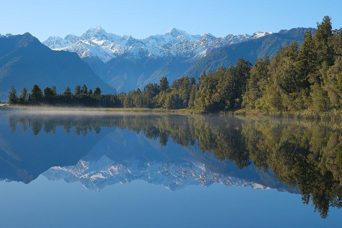
The first light at Lake Matheson does not arrive as light. It arrives as stillness. You stand on the jetty in the pre-dawn cold, the tannin-black water flat as poured glass, and then the sky behind Aoraki/Mount Cook and Mount Tasman begins to warm — and the two highest mountains in New Zealand appear twice, once in the air and once in the lake, thirty kilometres away and close enough to touch. Those peaks belong to the neighbouring park. You are standing in Westland Tai Poutini, on the wild West Coast, looking east into the Southern Alps you cannot reach from here. That geographic sleight of hand — rainforest at your feet, glaciers on the skyline, a mirror in between — is the signature of this coast, and it is only the beginning.
This guide covers the four national parks a photographer meets travelling New Zealand’s West Coast and North Island, and the roadside icons in between. On the South Island it is Westland Tai Poutini and Paparoa; across Cook Strait, Abel Tasman at the top of the South Island and Egmont / Taranaki on the North Island’s western bulge, plus the geothermal fields, sea caves and headlands that make the North Island worth the crossing. It is the complement to our companion guide to the South Island’s alpine interior — Fiordland, Aoraki/Mount Cook and Mount Aspiring — and it deliberately does not repeat them. Where that guide is about ice and altitude, this one is about coastline, tide, temperate rainforest, and one impossibly symmetrical volcano.
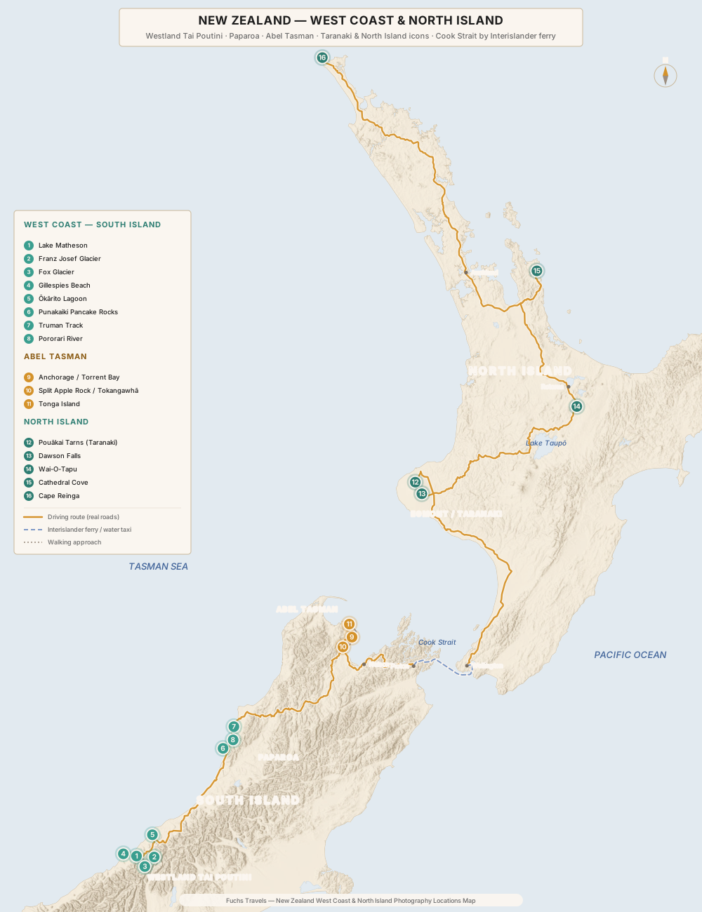
Westland Tai Poutini National Park
Westland Tai Poutini is the park where the ice meets the sea. In the space of forty kilometres the land drops from 3,000-metre peaks, through two of the most accessible glaciers on Earth, into temperate rainforest and out onto a driftwood coast. It rains here — five to six metres a year in the glacier valleys — and the light is forever moving. Treat that as the subject, not the obstacle.
Lake Matheson
GPS: ●●.●●●●° S, ●●●.●●●●° E
This is the reflection New Zealand puts on its postcards, and it earns the cliché. A one-and-a-half-hour loop track circles the lake through kahikatea and rimu forest to two viewing platforms — “View of Views” and “Reflection Island” — that frame Aoraki/Mount Cook and Mount Tasman over the water. The dark water is the trick: leaf tannins stain it near-black, which kills surface glare and deepens the mirror.
Best light: Dawn, without exception. The reflection needs still air, and the wind here builds through the morning, so the window is the first hour after first light. The peaks catch alpenglow before the forested foreground does — meter for the lit summits and let the trees fall dark. Shoot a symmetrical frame with the waterline dead-centre; this is one of the rare times centring the horizon is the right call.
Technique: Check the water surface, not the forecast — a “clear” morning with a breeze gives you nothing. A polariser will deepen or destroy the reflection depending on angle, so dial it slowly while watching the water. Bring a headtorch for the pre-dawn walk in, and expect company at the platforms in summer.
Franz Josef Glacier / Kā Roimata o Hine Hukatere
GPS: ●●.●●●●° S, ●●●.●●●●° E
Be honest with yourself and your readers about what these glaciers now are. A generation ago you could walk from the car park onto the ice at both Franz Josef and Fox. That era is over. Retreat and rockfall have severed the valley floors from the glacier tongues, and the only way onto the ice today is by helicopter heli-hike. On foot, the Franz Josef valley walk (around an hour each way, terrain and river permitting) still delivers you to a viewpoint of the terminal face across a boulder-strewn riverbed — the glacier now a distant blue tongue where it once loomed overhead. That distance is the photograph: shoot the scale of the empty valley, the moraine walls, the sheer evidence of a landscape in retreat.
Technique: Overcast is your friend on white ice — direct sun blows the highlights unrecoverably. Use a person or a lone boulder for scale; the valley eats wide lenses. River and rockfall conditions close the track without warning, so check the Department of Conservation and the Glacier Country daily update before you drive in.
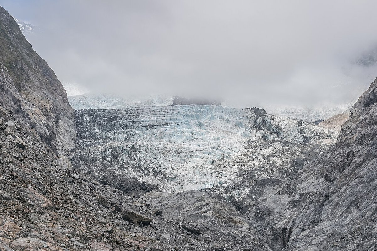
Franz Josef Glacier’s icefall under moving cloud — the ice is now reached only by heli-hike. Photo: Krzysztof Golik / Wikimedia Commons (CC BY-SA 4.0)
Fox Glacier / Te Moeka o Tuawe
GPS: ●●.●●●●° S, ●●●.●●●●° E
Fox is the cautionary tale. Where Franz Josef still offers a valley walk to a viewpoint, at the time of writing the Fox Glacier valley walk and terminal-face track are closed indefinitely after major landslips changed the river’s course and damaged the access road. Do not plan a foot approach to the Fox terminal face; assume it is closed and verify otherwise on DOC before you go. The ice itself is heli-access only. What Fox still gives the photographer is the drive and the nearby forest walks, and — twenty minutes away — Lake Matheson, which is really Fox Glacier’s reflection pool by another name.
Gillespies Beach
GPS: ●●.●●●●° S, ●●●.●●●●° E
A gravel road west of Fox village runs out to Gillespies Beach, a wild, grey-sand strand piled with bleached driftwood and backed, on a clear evening, by the Southern Alps catching the last light. This is the West Coast at its most elemental and least crowded — the place to shoot a sunset that includes both ocean and 3,000-metre peaks in one frame.
Best light: Sunset. The beach faces west into the Tasman Sea, so the sun sets over the water while the alps behind you glow. Technique: Use the driftwood as foreground leading lines into the surf, and consider a long exposure with a 6- or 10-stop ND to smooth the sea into mist against the hard timber. A polariser cuts the wet-sand sheen. Time your walk so you are not crossing the lagoon outlet in the dark.
Ōkārito Lagoon
GPS: ●●.●●●●° S, ●●●.●●●●° E
Ōkārito is New Zealand’s largest unmodified coastal wetland, a maze of tidal channels backed by rainforest and, on the horizon, the Southern Alps — the “rainforest meets ice” view in a single lagoon. It is the breeding home of the kōtuku (white heron), revered in Māori tradition and so rare it is proverbial; a kayak at dawn through the still channels is the way to see and photograph both the birds and the mirrored peaks.
Technique: A kayak from Ōkārito is the platform — quiet, low, and able to reach the reflective backwaters at first light. For the herons, bring a 100-400mm equivalent and respect the distance; a nesting kōtuku disturbed off the nest is a failure, not a photograph. For the landscape, the lagoon’s stillness at dawn mirrors the alps just as Lake Matheson does, with fewer people.
Paparoa National Park
Paparoa is limestone country: a coast of stacked, weathered karst where the Tasman Sea has carved caves, blowholes and gorges out of ancient seabed. It is compact, roadside-accessible, and defined by two things — the tide, and the nikau palm, New Zealand’s only native palm, which gives the rainforest here a subtropical look that surprises visitors expecting alpine grey.
Punakaiki Pancake Rocks and Blowholes
GPS: ●●.●●●●° S, ●●●.●●●●° E
The Pancake Rocks at Dolomite Point are stacked limestone formations — layer on layer, like grey flapjacks — riddled with blowholes that fire spray skyward when the sea drives into them. The whole spectacle lives and dies on timing. The blowholes perform at high tide combined with a westerly or south-westerly swell; at low tide or in calm seas they are a damp anticlimax. Get both conditions and you have drama; miss the tide and you have wet rocks.
Best light and timing: Check a Greymouth or Westport tide table and aim your visit at high tide. Because the biggest swells arrive with West Coast winter storms, June to August is the blowholes’ season even though the light is short. The Dolomite Point loop is a sealed 1.1-kilometre walk (around twenty to thirty minutes), wheelchair-accessible with assistance apart from one optional stepped section — so you can shoot the surge and be back at the car quickly if the weather turns, which it will.
Technique: A fast shutter (1/1000s and up) freezes a blowhole’s plume; a slower one (around 1/15s) with an ND smears the surge into motion. Shoot both. A polariser deepens the sea and cuts spray-sheen off the rock, but keep a microfibre cloth handy — the salt mist coats a front element in minutes.
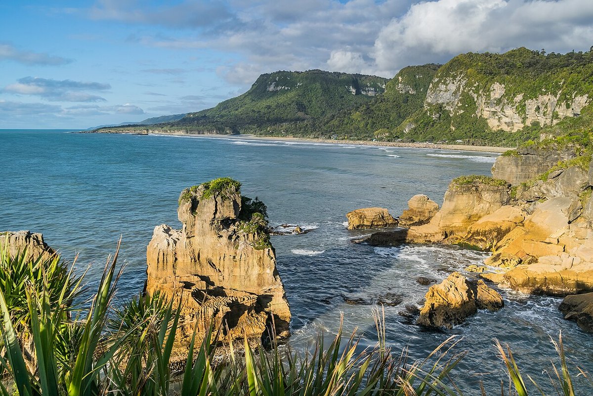
The limestone coast at Dolomite Point, Punakaiki — native flax anchors the foreground, the Paparoa Range rises behind. Photo: Krzysztof Golik / Wikimedia Commons (CC BY-SA 4.0)
Truman Track
GPS: ●●.●●●●° S, ●●●.●●●●° E
A short (fifteen-minute) walk through coastal nikau forest opens suddenly onto a small beach hemmed by overhanging limestone, a sea cave, and a waterfall that drops straight onto the sand at high water. It is one of the West Coast’s most photogenic pocket beaches and, like everything at Paparoa, tide-dependent: low tide opens the sand and the cave, so time this one opposite to the blowholes.
Technique: Low tide gives you the full beach, the cave mouth, and reflective wet sand for foreground. A wide lens takes in the cave-frame-to-waterfall composition; a long exposure turns the incoming surf to mist around the rock platforms.
Pororari River
GPS: ●●.●●●●° S, ●●●.●●●●° E
The Pororari River gorge is the quiet masterpiece of Paparoa. A flat, easy track follows a slow jade-green river between limestone bluffs draped in nikau palms and subtropical bush — a scene that looks more like a lost world than a New Zealand riverbank. It forms the coastal end of the multi-day Paparoa Track, the Great Walk opened in 2019, and even a half-hour stroll from the road delivers the signature frame.
Technique: This is a soft-light location — overcast or the shaded hours saturate the greens and let the reflections read; harsh midday sun through the canopy is a contrast nightmare. Get low to use the river as a mirror and leading line, and let a single nikau palm or the curve of the bluff carry the eye. A polariser controls the glare on the water and wet leaves.
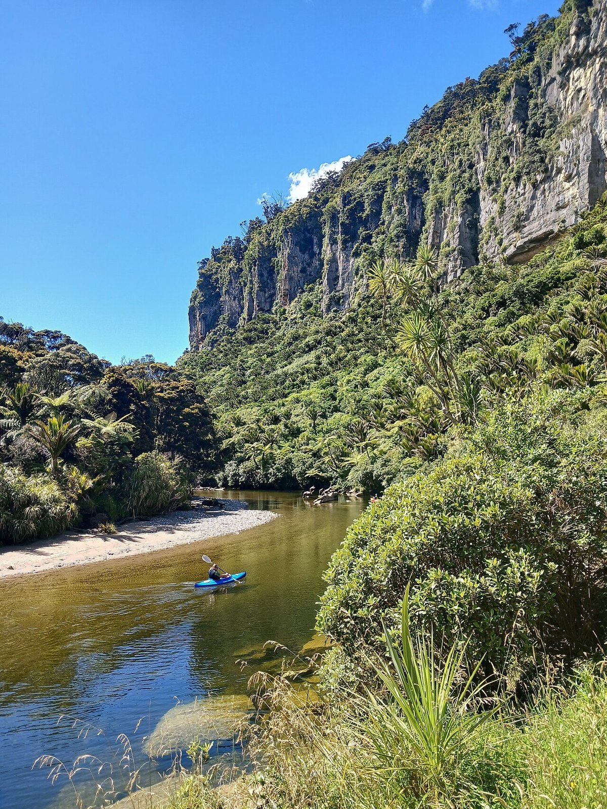
The Pororari River gorge — nikau palms and limestone bluffs above slow jade water, the coastal end of the Paparoa Track. Photo: Michal Klajban / Wikimedia Commons (CC BY 4.0)
Abel Tasman National Park
Abel Tasman is New Zealand’s smallest national park and its gentlest: a coastline of golden granite beaches, turquoise water and regenerating bush at the sunny top of the South Island. There are no roads inside it. You arrive and move by water taxi, kayak or on foot along the Coast Track, and the whole park runs on the tide — beaches appear and vanish, and one crossing can only be made at low water. Plan around the tide table and Abel Tasman is easy; ignore it and you are stranded.
Anchorage and Torrent Bay
GPS: ●●.●●●●° S, ●●●.●●●●° E
Anchorage is the classic Abel Tasman scene — a broad golden crescent of sand, moored yachts on turquoise water, forested headlands — and, with Torrent Bay across the estuary, the most-photographed stretch of the Coast Track. Water taxis from Kaiteriteri and Mārahau drop you here, which makes it the easiest section to shoot without committing to the full multi-day walk.
Best light: The beaches face broadly east and north, so early morning gives clean side-light across the sand and the calmest water for reflections; the golden granite genuinely glows at the ends of the day. Technique: Get up onto the Coast Track’s low headlands for the elevated bay-and-boats composition — the eye-level beach shot rarely does the colour justice. A polariser is close to mandatory here to saturate the turquoise shallows and cut surface glare.
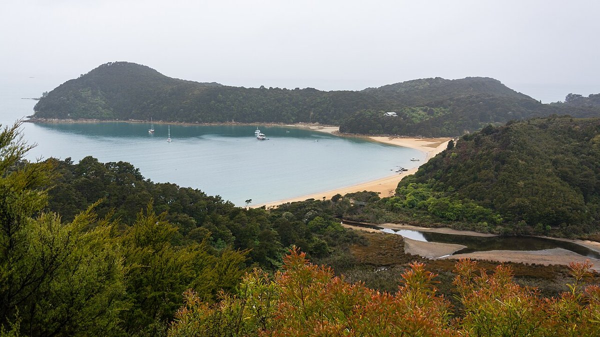
Anchorage Bay — a golden granite crescent reached only by water taxi or on foot along the Coast Track. Photo: Christoph Strässler / Wikimedia Commons (CC BY-SA 2.0)
Split Apple Rock / Tokangawhā
GPS: ●●.●●●●° S, ●●●.●●●●° E
Just outside the park’s southern edge, between Kaiteriteri and Mārahau, a Cretaceous granite boulder sits offshore in Tasman Bay cleaved cleanly in two — Tokangawhā, the Split Apple. It is small, famous, and best at dawn, when the low sun rakes across the split and the bay is glassy. Reach it by wading at low tide, by kayak, or by boat tour.
Technique: Compose to put the gap between the two halves against the brightening sky or a distant headland; the split is the whole subject, so use it as a natural frame. Dawn stillness gives you a reflection of the boulder in the shallows. A short telephoto from the beach compresses the rock against the far shore.
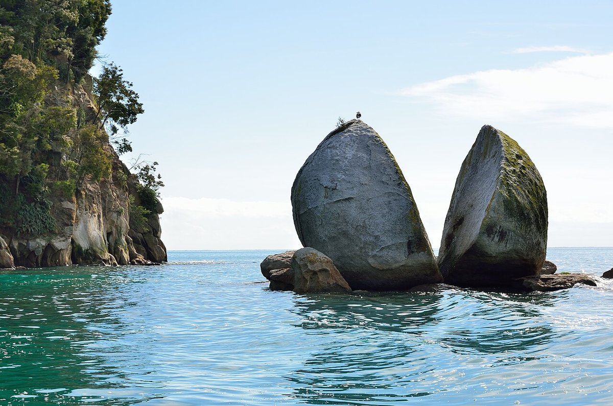
Tokangawhā / Split Apple Rock — a Cretaceous granite boulder split clean in two, best at dawn on glassy water. Photo: Tristan Schmurr / Wikimedia Commons (CC BY 2.0)
Tonga Island
GPS: ●●.●●●●° S, ●●●.●●●●° E
Off the coast between Bark Bay and Awaroa, little Tonga Island sits within the Tonga Island Marine Reserve and hosts a colony of kekeno (New Zealand fur seals) — pups included in summer. It is a kayak-and-water-taxi wildlife subject, not a roadside one, and it rewards a long lens and patience.
Technique: Shoot from the water with a 100-400mm equivalent; keep the legally and ethically required distance and let the seals behave naturally rather than chasing a fill-the-frame shot. Overcast flattens the harsh contrast between dark wet seals and bright granite. Steady yourself — long glass from a moving kayak demands a fast shutter (1/1000s or more).
Timing the crossings
Abel Tasman’s one non-negotiable is Awaroa Inlet, a tidal crossing on the Coast Track that can only be made around low tide — roughly 1.5 hours before to 2 hours after low water, in daylight. Miss the window and you wait hours for the next one. Carry a DOC tide table (or the printed times at the trailhead), and plan your walking day backward from Awaroa’s low tide, not from your own schedule.
Egmont / Taranaki National Park
Then there is the mountain. Rising 2,518 metres in near-perfect symmetry from the flat green Taranaki farmland, Mount Taranaki is the most photogenic volcano in the country — a solitary cone so clean it doubled for Mount Fuji on film. The park around it, a circular tract of rainforest and alpine herbfield, holds moss-draped “goblin forest,” waterfalls, and the single most sought-after reflection in New Zealand.
In January 2025 the mountain became a legal person. Under Te Ture Whakatupua mō Te Kāhui Tupua / the Taranaki Maunga Collective Redress Act 2025, the maunga and its surrounding peaks are recognised as Te Kāhui Tupua, a living legal entity that now owns the former Egmont National Park (renamed Te Papa-Kura-o-Taranaki). It follows the precedent of the Whanganui River, granted legal personhood as Te Awa Tupua under a 2017 act. Photograph Taranaki as what the law and local iwi hold it to be: an ancestor, not a backdrop.
Pouākai Tarns
GPS: ●●.●●●●° S, ●●●.●●●●° E
This is the shot. A cluster of small alpine tarns on the Pouākai Range, a few minutes beyond Pouākai Hut, holds a flawless reflection of Taranaki’s cone across the valley when the air is dead still — the image that launched a thousand trips. It is roughly a two-hour, five-kilometre climb up the Mangorei Track from the Mangorei Road end, then fifteen minutes past the hut to the tarns.
Strategy — the honest version: The reflection needs two things that rarely coincide — a cloud-free summit and windless water — and Taranaki makes its own weather, wrapping itself in cloud on otherwise clear days. Do not day-trip it and hope. Book Pouākai Hut (a bookable DOC hut, reserved online year-round at doc.govt.nz, around NZ$25 per adult per night; rebuilt and reopened in 2025) and stay the night. That puts you at the tarns for both dusk and dawn — two chances at the still window instead of none. Watch the mountain forecast and commit to the nights that offer a clearing.
Technique: Shoot low over a tarn with the cone as your top third and its reflection as the bottom. Dawn gives alpenglow on the summit and the calmest water; bracket for the range between lit peak and shadowed herbfield and blend by hand. The tarns are tiny and fragile — stay on the boardwalk and rock.
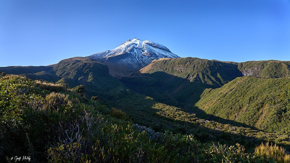
Mount Taranaki’s near-perfect cone from the Pouākai Range — the vantage that leads to the Pouākai Tarns reflection. Photo: Geoff McKay / Wikimedia Commons (CC BY 2.0)
Dawson Falls / Te Rere o Kapuni
GPS: ●●.●●●●° S, ●●●.●●●●° E
On the mountain’s south-eastern flank, Dawson Falls drops eighteen metres over a lava cliff into dense rainforest, reached by a short walk from the Dawson Falls road end. The surrounding “goblin forest” — kāmahi trees bent and bearded with hanging moss and lichen — is as good a subject as the waterfall itself, a green, dripping, otherworldly interior that begs for soft light.
Technique: Overcast or the shaded hours are ideal — the moss glows and the waterfall’s whites stay controllable. Use a tripod and a slow shutter (1/4 to 1 second) to render the falls silky; a polariser cuts the glare off wet leaves and rock. In the goblin forest, look for a single moss-draped limb or a tunnel of trees to impose order on the chaos, and let the damp, diffuse light do the work.
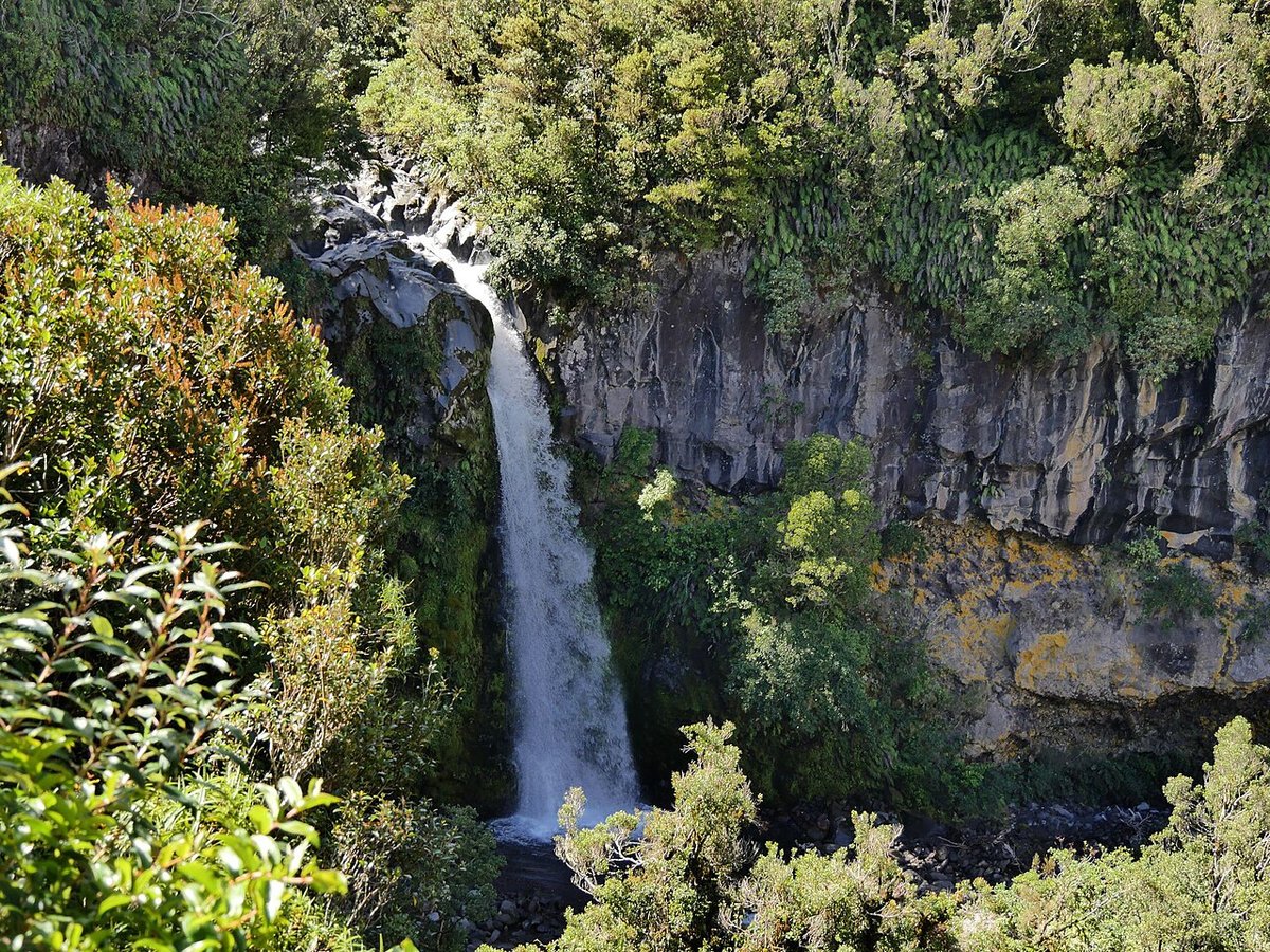
Dawson Falls / Te Rere o Kapuni pours over a lava cliff into the “goblin forest” on Taranaki’s flank — a soft-light subject. Photo: Ulrich Lange / Wikimedia Commons (CC BY 3.0)
Beyond the Parks: North Island Icons
The parks are the spine, but the North Island’s roadside and coastal landmarks are worth building into the route.
Wai-O-Tapu and the Rotorua Geothermal Fields
GPS: ●●.●●●●° S, ●●●.●●●●° E
South of Rotorua, Wai-O-Tapu Thermal Wonderland is the country’s most colour-saturated geothermal site, crowned by the Champagne Pool — a 65-metre-wide hot spring rimmed in bright orange antimony and arsenic deposits, its jade water forever exhaling steam. Get there at opening on a cold, still morning and the steam hangs thick over the pool before the sun burns it off.
Technique: Cold, calm, early — that combination maximises the steam that makes the shot. Shoot the graphic contrast of orange rim against green water; a slightly elevated angle from the boardwalk reads the pool’s shape best. A polariser can cut steam glare but also flattens the mist, so shoot both with and without. Protect your gear — geothermal areas are humid and mildly corrosive.
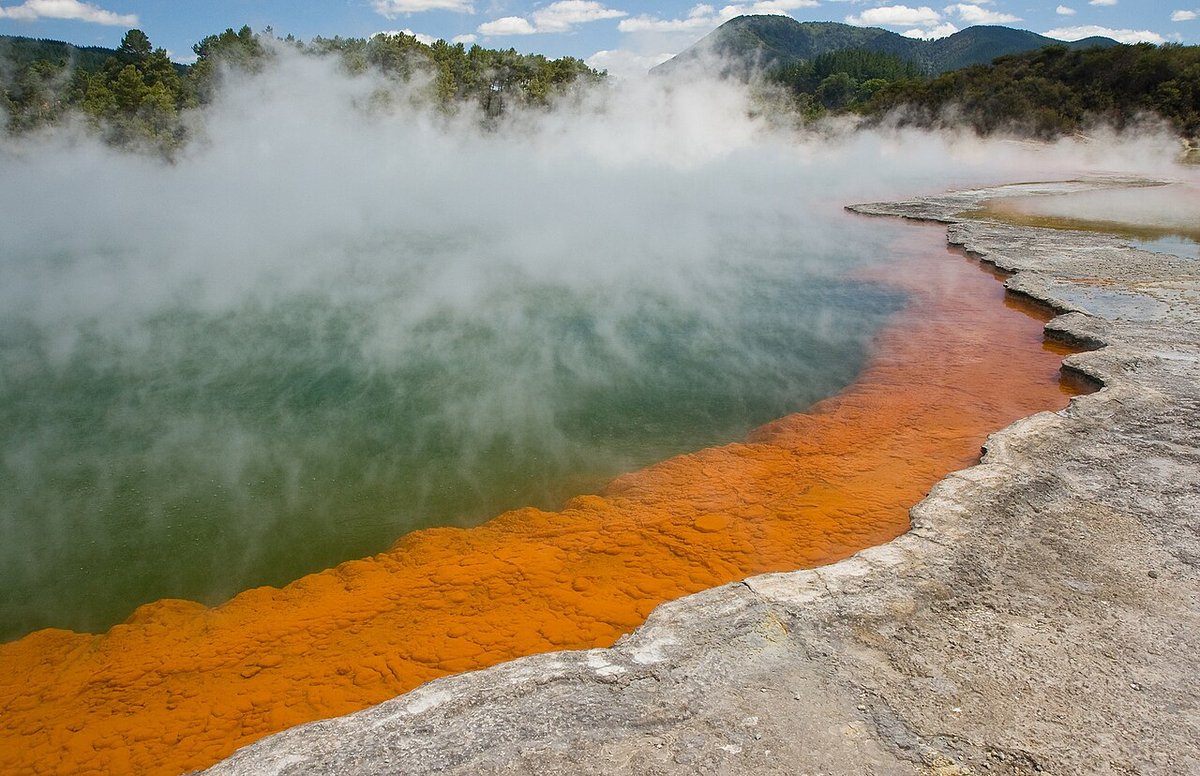
The Champagne Pool at Wai-O-Tapu — orange mineral rim, jade water, and the steam that comes off best on a cold, still morning. Photo: Christian Mehlführer / Wikimedia Commons (CC BY 2.5)
Cathedral Cove / Mautohe
GPS: ●●.●●●●° S, ●●●.●●●●° E
On the Coromandel Peninsula, Cathedral Cove is the iconic sea-arch beach — a vaulted limestone tunnel opening between two golden coves. Its access has been a saga: storm damage in 2022–23 closed the walking track, and it has since reopened, reclosed and reopened again as the naturally unstable cliffs are assessed. As of early 2026 the main Cathedral Cove walkway is open, but some side tracks remain closed and further closures can happen at short notice. Do not build a trip around it without checking the current status on DOC first — and treat boat or kayak access from Hahei as the reliable alternative.
Technique: Dawn is the play — the arch faces roughly east-north-east, so early light rakes through the tunnel and onto the sand, and you beat both the crowds and the tour boats. Frame the far cove through the arch as a natural vignette.
The rest of the route
Cape Reinga (GPS: ●●.●●●●° S, ●●●.●●●●° E), at the far north where the Tasman Sea meets the Pacific, offers a lonely lighthouse on a spiritual headland — Te Rerenga Wairua, the departing place of souls in Māori belief; shoot it with respect and at the day’s edges. Hobbiton, near Matamata, is a ticketed film set rather than a landscape, but a rewarding portrait-and-detail subject for those who want it. Tongariro National Park and its famous Alpine Crossing sit on the Central Plateau and are covered in our companion South Island and central-plateau notes — worth the detour if your route runs through the middle of the island. And the Whanganui River — Te Awa Tupua — offers a multi-day canoe journey through gorge and bush for photographers who want to travel their subject rather than visit it.
Seasonal Photography Calendar
New Zealand’s seasons are inverted: summer is December to February, winter June to August. Each has a distinct character on this coast.
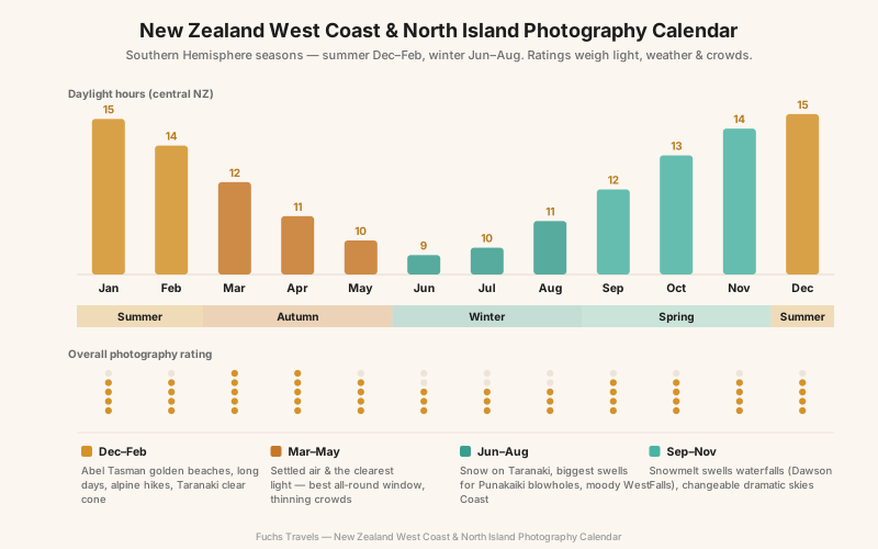
| Season | Months | Character | Best for |
|---|---|---|---|
| Summer | Dec–Feb | Warmest, longest days, busiest; Abel Tasman at its best | Beaches, kayaking, long alpine days, clear-cone Taranaki |
| Autumn | Mar–May | Settled air, the clearest light, thinning crowds | Reflections, the best all-round window |
| Winter | Jun–Aug | Snow on Taranaki, biggest swells, short moody days | Punakaiki blowholes, snowy cone, dramatic West Coast |
| Spring | Sep–Nov | Snowmelt swells the waterfalls, unstable changeable weather | Dawson Falls, dramatic skies, fewer people |
Autumn (March to May) is the connoisseur’s window: the air is more settled than spring, the light on the coast is at its clearest, and the summer crowds have broken. Winter is counterintuitively strong here — the West Coast’s biggest storm swells fire the Punakaiki blowholes, and Taranaki wears snow — but daylight is short and the glacier valleys flood. Summer is for Abel Tasman’s beaches and the best odds of a cloud-free Taranaki cone, at the cost of company. There is no single best month; there is only the season that matches the picture you came for.
Technique: Reading the West Coast Light and Tide
Two disciplines separate a good West Coast trip from a frustrated one.
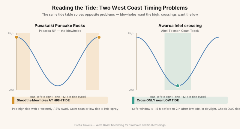
The tide is a tool with two settings. The same tide table that tells you when to shoot the Punakaiki blowholes — high tide, paired with a westerly swell — tells you when you can cross Awaroa Inlet in Abel Tasman — low tide, in daylight. Learn to read it as a photographer, not just a walker: high tide fires the blowholes and floods Truman Track’s beach, low tide opens the sand and the sea caves and the crossings. Check a regional tide table (Greymouth and Westport for Paparoa; the DOC Abel Tasman tables for the crossings) and build your day around the water, not your watch.
The light here is fast and clear. New Zealand’s air is famously clean — thin ozone, little dust, a hard clarity that makes shadows deep and colours saturated, and that punishes a lazy exposure. Weather fronts sweep off the Tasman in minutes; the West Coast’s gift is the clearing, the moment a storm lifts and light pours through torn cloud onto wet rock and sea. Keep the camera out in the weather under a rain cover, watch the western horizon, and treat every clearing as a two-minute window you cannot recall. Overcast is not a failure on this coast — it saturates the rainforest greens and the golden granite and lets the waterfalls read.
Drones, Permits, and Ethics
Be clear-eyed before you pack a drone. Two separate rule sets apply, and photographers routinely get the second one wrong.
First, Civil Aviation Authority Part 101 governs the airspace for recreational flight: keep below 120 metres, maintain visual line of sight, fly only in daylight, stay clear of people and property without consent, and keep well away from aerodromes. Second — and this is the trap — the Department of Conservation requires a concession (permit) to take off from, land on, or hover over any public conservation land or water, national parks included, even for personal use. It is not a blanket ban, but DOC zones conservation land green, orange or red; most of the high-value scenery in these parks falls in the orange or red bands, where permits are slow, expensive, or simply declined. The recreational green-zone permit fee runs around NZ$180–210 at the time of writing. Rules and zones change — check DOC’s drone map for the specific location before you plan any flight, and assume the iconic spots are off-limits.
Beyond the law, there is the ground itself. The alpine tarns at Pouākai and the cushion herbfields take decades to recover from a bootprint — stay on the boardwalks. Taranaki is a legal ancestor and Cape Reinga a sacred departing place; kōtuku on the nest at Ōkārito and fur seals at Tonga Island are protected wildlife, not props. Photograph all of them as a guest.
Logistics and Planning
Getting there: The West Coast parks pair naturally with a South Island road trip — Christchurch over Arthur’s Pass to the coast, or up from Queenstown and the glaciers. Punakaiki sits on the coast road north of Greymouth; Abel Tasman is reached via Nelson and Mārahau. For the North Island, fly into Auckland (for Coromandel and the far north) or Wellington, with New Plymouth the base for Taranaki and Rotorua the base for the geothermal fields. Crossing between islands is the Interislander or Bluebridge ferry across Cook Strait (Picton–Wellington), or a short domestic flight.
Where to stay: Franz Josef and Fox villages for the glaciers and Lake Matheson; Punakaiki or Greymouth for Paparoa; Mārahau, Kaiteriteri or Nelson for Abel Tasman; New Plymouth or Stratford for Taranaki; Rotorua for the geothermal fields.
| Tier | Per night (NZD) | Example |
|---|---|---|
| Budget | $35–90 | DOC campsites, holiday-park cabins, hostels |
| Mid-range | $150–280 | Motels and lodges in Nelson, New Plymouth, Franz Josef |
| Premium | $350+ | Boutique lodges, Abel Tasman eco-retreats |
| Daily cost (two photographers) | Estimate (NZD) |
|---|---|
| Accommodation (mid-range) | $170–260 |
| Rental car + fuel | $70–110 |
| Food | $80–120 |
| Water taxi / kayak / hut (as needed) | $0–220 |
| Daily total | ~$320–710 |
Allow ten to fourteen days to link the West Coast parks with Abel Tasman and Taranaki without racing the weather; the tide and Taranaki’s cloud both reward patience over pace.
Gear Recommendations
This is a coastal, rainforest and reflection landscape with genuinely wet weather. Prioritise sealing, filters and a solid tripod over exotic focal lengths.
| Category | Recommendation | Why |
|---|---|---|
| Body | Weather-sealed mirrorless (full-frame ideal) | West Coast rain, salt spray, geothermal humidity |
| Wide zoom | 16–35mm f/2.8–4 | Gorges, beaches, reflections, sea caves |
| Standard/tele | 24–70mm + 70–200mm | Isolating Taranaki’s cone, blowhole plumes |
| Wildlife | 100–400mm | Kōtuku at Ōkārito, fur seals at Tonga Island |
| Filters | Circular polariser + 6/10-stop ND | Reflections, waterfalls, silky surf, turquoise water |
| Tripod | Carbon, load-rated for wind | Dawn reflections, long exposures, alpenglow brackets |
| Protection | Rain cover, microfibre cloths, blower, dry bags | The coast will soak you; salt and steam corrode |
Pack layers for alpine cold at the Pouākai Tarns even in summer, and quick-dry footwear you are willing to wade in — Abel Tasman’s crossings and Split Apple Rock both mean wet feet.
Field Exercises
- The still window: At Lake Matheson or the Pouākai Tarns, arrive 45 minutes before dawn and shoot the same symmetrical reflection every five minutes until the wind kills it. Study the sequence to learn how brief the mirror really is.
- Read the tide both ways: On one Paparoa day, shoot the Punakaiki blowholes at high tide and Truman Track’s beach at low tide. Return with a frame that could only have been made at each state of the water.
- Shoot the clearing: Spend a wet West Coast morning out in the weather without waiting for it to stop. Come home with five keepers made in the rain — waterfalls, misted bush, a storm lifting off the sea.
- Scale the glacier valley: At the Franz Josef viewpoint, make an image whose subject is the distance to the ice — the empty valley, the moraine, a human figure for scale — not a pretty close-up of blue ice you can no longer reach.
- One respectful wildlife frame: At Ōkārito or Tonga Island, make a single strong image of a kōtuku or a fur seal from an ethical distance, with the animal behaving naturally — no baiting, no crowding, no chase.
Conclusion
The South Island’s alpine interior gives up its pictures to altitude and patience. This coast asks for something different: a reading of water. High tide or low, still air or wind, storm or the clearing that follows it — the West Coast and the North Island reward the photographer who learns to time the sea and the sky rather than fight them. The glaciers are retreating and the access is changing, Cathedral Cove opens and closes with the cliffs, and Taranaki hides in its own cloud more days than not. None of that is an obstacle. It is the reason a cloud-free cone mirrored in a windless tarn, or a blowhole firing white against a grey winter swell, feels earned when you finally make it.
Go with the tide table in one pocket and the mountain forecast in the other. Stay the extra night. Watch the western horizon. This is not a coast that hands you its best light — but stand on the Lake Matheson jetty at dawn often enough, and one still morning it will double the highest mountains in the country at your feet, and you will understand why it was worth every wet one before it.
Plan the trip — Compare New Zealand month by month in the Seasons Planner, read the Complete Guide to Long Exposure for the blowholes and waterfalls, or see the New Zealand South Island photo tour run by Aerial Media.